Everest 2#
by Ivan Roslyakov,
member of the AirPano Team that is a member of the global-geography Consortium.
20 March 2013
with kind permission of AirPano
Nepal is lucky to have so many extraordinary landmarks. Not only that Nepal is known as the birthplace of Buddha, it also has the majority of highest mountains in the world: 8 out of 14 8K Peaks are located here. Among them is Mount Everest, the highest mountain on planet Earth.
It is also known as Chomolungma (or Qomolangma), which is Tibetan for "Holy Mother." The name "Everest" comes from Sir George Everest, the Surveyor General of India, a division of the British Raj in India, only because in 1852 survey department workers measured the height of Chomolungma for the first time, showing Peak XV to be the tallest mountain in the entire region and, probably, in the world.
However, the height of Mount Everest is not that obvious. Radhanath Sikdar, an Indian mathematician and topographer, who worked in the above-mentioned institution 240 kilometers away from the mountain, only made an assumption based on trigonometric calculations that Chomolungma is the highest mountain in the world. 4 years later actual surveys showed the height to be 29,002 feet (8,840 meters), proving Radhanath Sikdar's theory.
After that people measured Mount Everest over and over again. There were cases when the mountain "grew" even taller — up to 8,872 meters depending on a measurement method. Today its official height is 8,848 meters above sea level, including 4-meter snowcap.
Here in the land of rocks, snow, and perpetual ice, atmospheric temperature drops down to minus 60 ° Celsius; and at the top of the mountain winds blow at 200 km per hour. At 7,925 meters altitude you enter the "dead zone" where oxygen level drops to 30%. To top it off there are constant ice slips and snow slides, so it is not surprising why no one could reach the summit for such a long time. Even now with advantages of modern technology, the ascent takes about two months, because it happens in several stages, including setting up a camp for altitude acclimatization.
Geographical location Chomolungma on the border of Nepal and China (Tibet) has always been yet another obstacle in conquering the mountain. Time to time Nepal, China, or both countries closed their borders to foreigners. One way or another, first successful ascent was accomplished by sherpa Tenzing Norgay and New Zealander Edmund Hillary in May 29th, 1953, after a long streak of failures of previous expeditions.
As of today there are about 4,000 people who reached the summit of Mount Everest (meaning those who made it to the top). And it's impossible to tell the number of tourists going on shorter routes. Many of those, who made it to the "roof of the world", set some kind of a record: climbing without oxygen tanks, staying without oxygen for almost a day, and skiing down Mount Everest... In 2001 blind American mountaineer Erik Weihenmayer reached the top of Mount Everest; and in 2006 Mark Inglis became the first double amputee to reach the summit. In 1976 Junko Tabei from Japan became the first female mountain-climber to conquer Chomolungma.
However, Mount Everest can be rightfully called a mountain of death. Taking on the challenge of climbing Mt. Everest, a mountaineer knows that he may not come back. He can die of heart failure, lack of oxygen, frostbite, or injury. He can also face such deadly accidents, as frozen valve of an oxygen tank. Furthermore, the trek to the top is so difficult that Alexander Abramov, member of Russian Himalayan expedition, once said, "At altitude of 8,000 meters one can't afford the luxury of morality. Once you reach 8,000 meters mark you are capable of thinking only of yourself, and simply don't have strength to help your companions. " In May 2006 a tragedy occurred on Mount Everest that shocked the entire world: 42 climbers cold-heartedly passed by David Sharp, a slowly freezing British climber, and none of them tried to help him. Some of them were members of Discovery Channel film crew — they attempted to interview the dying man, took some pictures of him, and left him behind...
But nothing can stop those, who want to push their limits and see the indescribable beauty with their own eyes. Our photo expedition to Mount Everest also got its share of troubles.
So now we would like to turn the floor over to Ivan Roslyakov, a person who created this virtual tour.
Where do our dreams take us? Dreams take us to the best things that matter the most, and to the highest accomplishments in our lives.
Our team has been thinking of shooting the highest mountain in the world for a few years. In January 2012 we gave it a first try. Our colleague Dmitry Moiseenko was able to shoot a high-altitude virtual tour of Sagarmatha National Park at the foot of Mount Everest.
When approaching Mount Everest, Dima faced insurmountable obstacle in the form of a strong headwind. This is why he wasn't been able to shoot the highest mountain in the world up close.
We had a year to prepare for the second try.
Everything almost worked out in spring of 2012. A few helicopter companies in Nepal employed powerful high-altitude helicopters designed to rescue people at the altitude of more than 6,000 meters. We arranged a personal meeting with the pilot who was willing to take us to the Valley of Silence (alpine valley at the foot of Mount Everest which is located at the altitude between 6 and 7 kilometers) and discussed details of the photo shoot. However, we couldn't obtain official shooting permit for spring due to several expeditions climbing the mountain. The weather at that time of the year was most favorable for climbing Mount Everest, and high-altitude helicopter could trigger snow slides putting climbers at risk.
Our next shooting attempt in the fall failed for the same reasons.
Then winter arrived. When I thought about all the troubles that our colleague went through last time I realized that we had little chance of success. Despite that I decided to go on a winter expedition to Mount Everest in order to shoot it like no one ever did before.
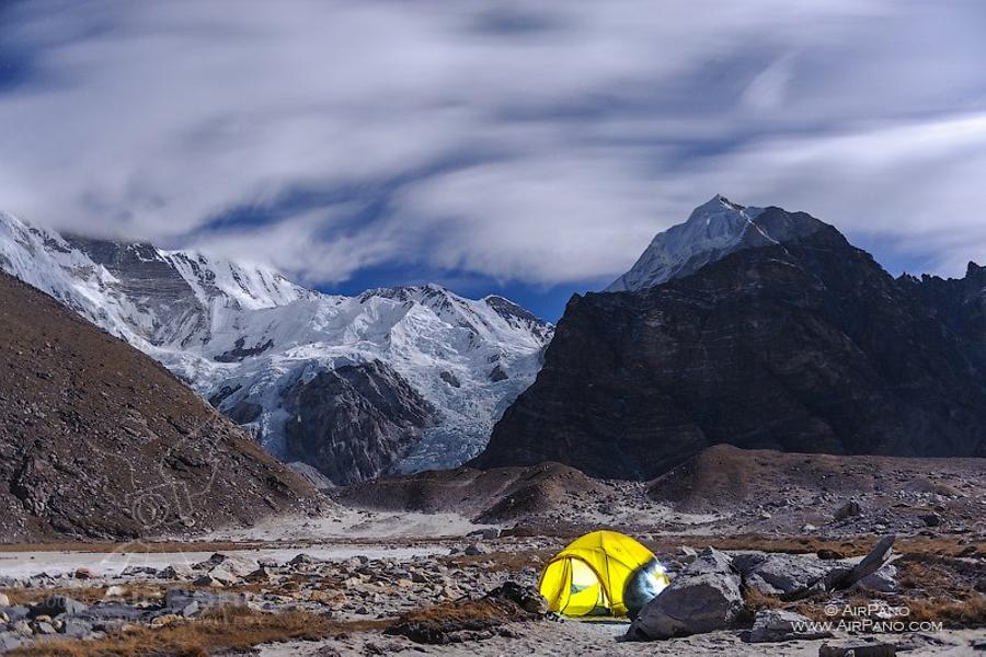
Everest region is the very first region I visited in Nepalese Himalayas several years ago and it made a lasting impression on me. Since then I was able to go on several mountain expeditions in central Himalayas and walked the total of more than 1000 kilometers down different mountain trails. Each of those expeditions took about a month and they prepared me for long trips, staying in tents and other harsh conditions. I crossed a lot of high mountain passes. I was able to see all of the highest mountains of Nepal with my own eyes from observation view-points and peaks located at altitudes of 5000-6000 meters.
This mission required me to go to the familiar Sagarmatha National Park and from there to the track leading to the foot of Everest. On one hand the Park had a well-developed infrastructure (after all it's the most popular mountain track in the world!), on the other hand, due to winter period, few tourists visited this location that time of year. Local residents went down to the warm valleys and by doing so they significantly reduced the number of open lodges (small stone houses that were blown through by mountain winds between finger-thick cracks and holes in the masonry), where you can stay for the night. So I had to use my tent again.
Winter weather can be very unpredictable. And I was the one to experience that. Upon arrival in Kathmandu, capital of Nepal, I found a group of tired tourists who were waiting for a plane or helicopter that would take them to their tracking routes. A very thick fog covered Kathmandu Valley for a couple of days, so all mountain flights were canceled, and weather forecast was not reassuring.
In order to keep up with my schedule I decided to go to Lukla, a small airport near Mount Everest, on my own. It took me a whole day of driving down narrow serpentine roads and a few days of hiking along narrow and steep mountain trails. To save some time, we agreed that helicopter pilot would fly to Lukla, spend the night at a local hotel, and in the morning we'd set off for the mountain.
It's hard to describe my excitement before departure! But circumstances were against us: the pilot didn't make it to Lukla. In the end I decided to take a mountain track to Mount Everest for better acclimatization, and helicopter would pick me up on the way there. I was lucky that in almost every village where I could stay for the night there was a helipad.
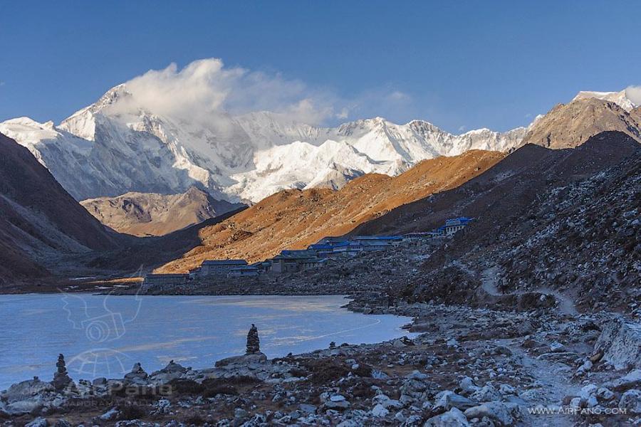
For several days one could see a lonely Russian tourist with several cameras hanging on his neck standing on high mountain helipads expecting "iron bird" that would never arrive. The mission was postponed due to weather conditions or some technical issues: helicopter required special preparation. Only when I reached Gokyo settlement, located at altitude 4700 meters in the neighboring valley near Mount Everest, I received a call from the pilot that he would pick me up the next morning. But it turned out that the pilot who knew all the details of this difficult flight was still busy. The one who was supposed to pick me up was an American guy whose name was Aaron Oberlander, and who just recently arrived to Nepal in order to train local pilots.
We planned our shooting on 25th of December, Catholic Christmas day. Fortunately for us, there were no winter expeditions on the mountain at the time. The forecast promised us cloudless weather in the region, and the weather service promised weak winds (50 km/h) near Mount Everest peak. Everything was in our favor.
What happened after could be only described as anxious hours of preparation, short sleep interrupted by auditory hallucinations of approaching helicopter, and agonizing minutes of waiting on a small spot on the field (a village helipad) early in the morning. Finally I heard the sound of rotating propellers and it was no longer a fantasy. A few minutes later a tiny red dot appeared in the sky. It took only 10 minutes for a helicopter to cover the distance that took me 3 days to traverse on foot.
And finally it landed near the high mountain lake, interrupting morning silence and attracting attention of local people, it was the most advanced helicopter from Nepalese fleet. It took some time to get acquainted with the pilot and discuss technicalities and we set off for the Mount Everest.
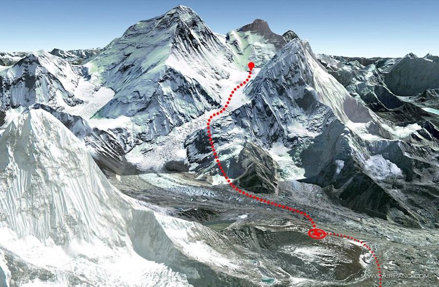
After we left Gokio we needed to gain altitude of 6000 meters in order to cross high mountain pass Changri-La. After that we needed to land on the slopes of the popular tourist peak Kala Patthar located at the altitude of 5200 meters (the highest point on the track to Mount Everest) in order to unload the fuel supply needed for the way back. We had to get rid of all the unnecessary equipment from the cabin in order to reduce weight.
Mechanics went a little overboard with pre-flight preparations leaving only one oxygen cylinder for the pilot and forgetting about the passenger. Later I realized that even after a week of trekking and climbing 5 kilometers up, my body wasn't prepared. So when we were flying over the mountain pass on the way to Mount Everest oxygen starvation was affecting my thoughts and actions.
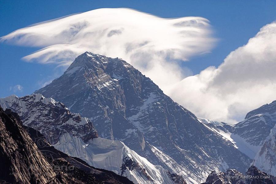
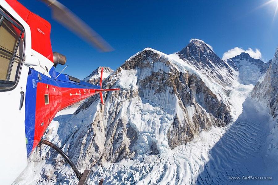
After a few minutes of preparation we began ascent to our goal. Rapidly gaining altitude, helicopter crossed Nuptse wall, an obstacle that blockes the view of Mount Everest from ordinary tourists: its lowest part is 6500 meters tall and allows only a small part of the summit to be visible to travelers. And finally we reached Valley of Silence.
Flying over one of the highest glaciers in the world, we moved along the southern route, most popular among conquerors of Mount Everest.
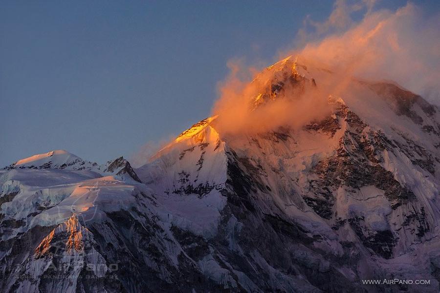
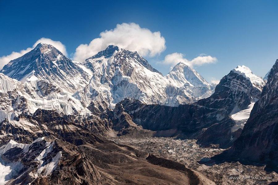
Just behind the wall of Nuptse (at the top of the Khumbu Icefall) there is a place where one sets up the first high-altitude camp (6050 meters); the second camp is being set up in the center of the ice gorge on a stone ridge (6500 meters); then we approached ice wall of Lhotse (4th highest mountain on the planet that is 8516 meters tall) where climbers set up the third high-altitude camp (7100 meters).
For your information: climbers set up the fourth camp at altitude of 8,000 meters on the south saddle between Everest and Lhotse: it's the final point before conquering the mountain peak (8848 meters).
In the distance far behind us we could see 7K peaks. But even at helicopter's maximum altitude we still felt like a tiny dragonfly in a gigantic gorge: we were surrounded by walls that were a few kilometers higher than our ultimate trajectory.
However, we didn't have time to enjoy the view. All our attention and remaining strength were spent handling photo equipment in conditions of the thin mountain air that made me suffer from altitude sickness bouts. Bright sunlight dazzled my eyes and made me push wrong buttons on the camera and menu settings became blurry. I won't be shy and tell you a real story: in between panorama shooting sessions I threw up on six-kilometers-height glaciers.
For the pilot Aaron Oberlander this flight was a serious test as well: he established his own high altitude record by exceeding the limit of 7000 meters set by the helicopter manufacturer, and all that time he spent in a company of a restless passenger who was opening helicopter door endless number of times.
Helicopter was constantly moving because it was impossible to hover at that altitude, and on top of everything I had to shoot spherical panoramas by a single camera.
All in all the entire flight was successful. The mountain accepted us and most importantly let us go home! There was only one single occasion when I became really scared: when a strong gust of wind shook our helicopter at the altitude of 7000 meters on the way back from the Valley of Silence and to the Khumbu Icefall.
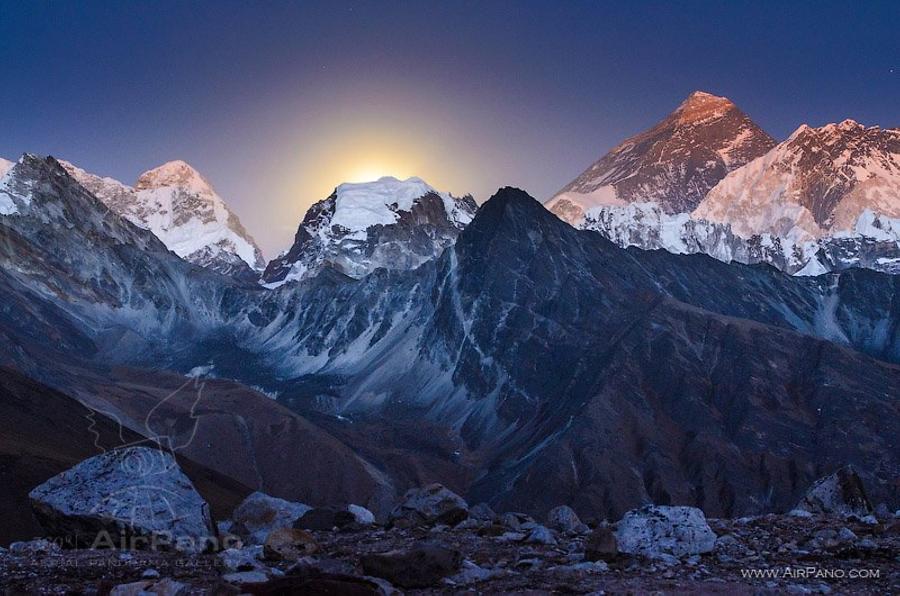
We turned around to go home just on time. Looking back, I noticed solid clouds over the highest mountain in the world, and strong wind started blowing icy dust from the top. The mountain was closed for flights.
Next revitalizing stop was at the refuel spot where I laid my hands on the life-giving oxygen cylinder while pilot was filling up the tanks. A short healing moment of piece and we were on our way back. Another 6000 meters and we were looking at the mountain pass Changri-La; we flew into an equally impressive gorge of glacier Ngozumbo (the longest glacier in the central Himalayas), dominated by the walls of another 8K Cho Oyu (8201 m), and several lower peaks with difficult to pronounce Tibetan names.
It was much easier and safer to work at lower altitudes.
On the way back we flew over high mountain lakes of Gokio that were rarely seen by tourists. I couldn't help but notice the beauty of emerald water that could be noticed even through a thick winter ice. These aerial photos were extremely useful later on and allowed me to make a walking route leading to one of valley's lakes (nameless lake # 8), virtually unnoticeable from the satellite images. But that's another story.
And now I would like to show you the highest-altitude spherical panoramas in the history of photography (taken from a helicopter) and featuring the highest mountain on the planet!
From the Editor:
I must mention that what Ivan said is not entirely true. At present our weather balloon flew a little bit higher than him and took pictures of Earth from the altitude of 35 kilometers. However, those pictures were made by "simple" cameras, not professional ones.