Hawaii, Oahu Island Virtual Tour#
by members of the AirPano Team that is a member of the global-geography Consortium.
Panoramas by Dean Karamehmedovich, programming by AirPano
2 December 2011
with kind permission of AirPano
There are 50 states in the USA. The newest state is Hawaii: these are remarkable islands located in the central part of Pacific Ocean, far away from the continent.
The Hawaiian archipelago consists of twenty four islands and atolls, as well as numerous small islands. These islands became inhabitant in VI century B.C., but for many centuries during the legendary round-the-world travel of the era of Great geographical discoveries, sailors passed either to the south or to the north of the islands. Therefore Hawaiian Islands didn't appear on the map for a long time and no one knew about them.
It is considered, that the first European who set foot on their land, was the famous sailor James Cook in 1778. He died a year later in the same place.
The main places of interest on Hawaii are beaches and the amazing nature: volcanoes, waterfalls and national parks. Besides, you can find a rich and extremely beautiful underwater world here. In general, Hawaii isn't called «paradise islands» in vain — it seems that both weather, and the magnificent nature and the beaches of Hawaii are specially created to awaken people's senses.
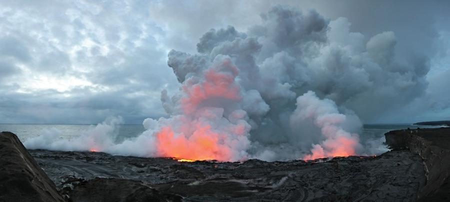
At present time the volcanic activity on Hawaiian Islands mainly happen in Kilauea: the attached crater located on a slope of Mauna Loa, the second highest mountain. The ongoing eruption of this volcano has been continuing since 1983. This volcanic eruption is famous for its spectacular fountains of the lava throwing the heated red magma 90 meters up in the air. Such lava fountain can sometimes reach the height of 500 meters. Leaving the crater, lava flows downhill like the bright-red river of basalt with the speed of 30 and more kilometers an hour. It burns absolutely everything on its way, cuts roads, and having reached the sea, it cools down quickly, sending huge pillars of vapor to the sky. For the tourists visiting this tropical paradise these eruptions are an absolutely unforgettable show.
We have already attempted to photograph the volcano eruption, but it's been only partially successful. The day when we have arrived there by the helicopter, lava pipes blocked up, and for the first time in several years the lava stopped flowing into the ocean. Next day the lava has made a new path, and by the time we found the place where lava was flowing into the ocean, a hundred-meter pillar of vapor was already rising there. By that time our helicopter was gone, and we took pictures only from the ground.

This is the reason why our interest in Hawaiian Islands hasn't diminished for several years.
Last year we met with Dean Karamehmedovich, a wonderful photographer who lives on the islands. He has been shooting the islands for a long time. You can find an interesting virtual tour across Hawaii here.
And today we present to your attention his aerial photo tour of the Oahu Island.

Because it is a first Dean's tour on our website, we would like to tell couple of words about Dean.
Like many other graduates, he has changed careers over the years from Electrical Engineer into Web-Developer, from Restaurant Owner to Photographer. Become adventure junkie, marathoner, triathlete, coffee drinker, traveler, new media strategist, self-confessed geek and motorcyclist he moved to Hawaii in 2000, the land of hula skirts, big waves and scuba-diving which is another one of his passions. He soon established VTHawaii.com. He landed his first big project in 2004 for Hickam Air Force base on Oahu and then became a full time professional photographer and the leading provider of panoramas in Hawaii.
In the year 2008 VTHawaii was awarded a contract from largest Real Estate company to photograph 1200 geo coded locations from the main Hawaiian islands, every community, every beach and every attraction and my ride begin..
In the year 2009 travel continue extensively to Canada and USA photographing hundreds of hotels in more that hundred cities beginning with CA, AZ, NM next to NY, MN, MI, NH, MA, then Canadian provinces like OT, BC, AB, MB, SK, QC, NB, NS and up to PEI and Newfoundland. He was also inspired to start doing underwater panoramas and even start his own marine life tribute website HawaiiMarineLife.com taking underwater images of endemic Hawaiian marine species.
Recently, AirPano.ru inspired him and after few trial runs from the airplane and helicopter the first demonstration aerial project was successful and VT Hawaii.com was airborne.
What's next?... There are many places to go!