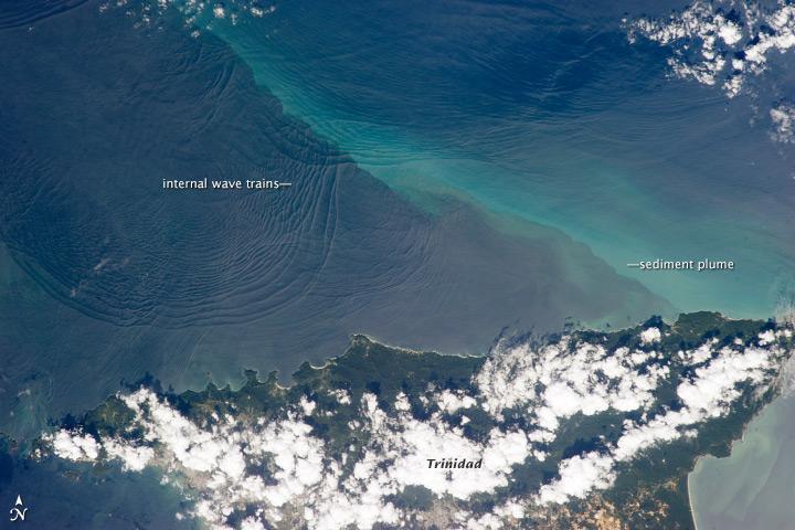
North coast of Trinidad #

Internal waves produce enough of an effect on the sea surface to be seen from space, but only where they are enhanced due to reflection of sunlight, or sunglint, back towards the space station. The image shows at least three sets of internal waves interacting. The most prominent set (image top left) shows a packet of several waves moving from the northwest due to the tidal flow towards the north coast of Trinidad.
Two less prominent, younger sets can be seen further out to sea. A very broad set enters the view from the north and northeast, and interacts at image top center with the first set. All the internal waves are probably caused by the shelf break near Tobago (outside the image to top right).
The shelf break is the step between shallow seas (around continents and islands) and the deep ocean. It is the line at which tides usually start to generate internal waves. Over the island of Trinidad, the heating of the land surface sets off the growth of cumulus clouds. Off the coast, a light blue northwest-southeast trending plume at image center is sediment embedded in the Equatorial Current (also known as the Guyana Current).
The current is transporting material to the northwest - in almost the opposite direction of the internal waves. The current flows strongly from east to west around Trinidad, all the way from equatorial Africa, driven by year-round easterly winds. Seafarers in the vicinity of Trinidad are warned that the current - and its local reverse eddies - make navigation complicated and sometimes dangerous for smaller craft in these waters.
Astronauts also have observed internal waves in other parts of the world, such as San Francisco and the Straits of Gibraltar.